
If you’re stuck for time – or thigh power – these iconic day hikes squeeze a week’s worth of scenery into less than 24 hours…

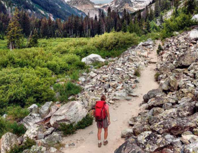
1FIMMVO RDUHALS HIKE, ICELAND
All the island’s oddness in microcosm
LENGTH: 25km
DIFFICULTY: Tough
Iceland is wonderfully weird. And a whole lot of that
weirdness is squeezed into this testing trail, which
starts near the ocean and ends amid the Thorsmork
mountains. Completing this in one day is tough – and
some choose to take two, overnighting at the halfway hut
– but it’s doable, especially if you hike in July and August
when the light lasts forever and the weather is at its best.
The trailhead is above staggering Skogafoss, one of
Iceland’s finest falls. It can be busy, but you’ll soon lose
the crowds, hiking northwards across the river-cut
grassy tundra via 20-odd more waterfalls and onto

outer space. This glacier-licked realm is ruled by two
huge, rambunctious volcanoes – Katla and the infamous
Eyjajallajokull – which are constantly sculpting new
steamy craters, lava fields and pumice piles. The views
from the trail’s highpoint (1,068m) are possibly the best
in Iceland, and followed by a descent into ‘Thor’s
Valley’, an area of towering icy peaks, crystalline rivers
and some of Iceland’s most beautiful hiking.
(17km), a classic ridge trail that runs right through
Jotunheimen National Park, with access to the
trailhead easily available by boat. ⊲
2SENTINEL PEAK
SOUTH AFRICA
The quickest (and easiest) way up the dramatic Drakensberg
 LENGTH: 12km
DIFFICULTY: Moderate
If you want to probe the upper heights of KwaZulu-Natal’s
uKhahlamba-Drakensberg escarpment but only have a day to
do it, this is the trek to pick. By driving up to Sentinel Peak car
park (2,600m), you can bypass a lot of climbing, leaving more
time for the good, high stuf; from the trailhead, there’s ‘only’
570-or-so metres to ascend to reach the top of the range.
At first the route rises via steep zigzags, basalt clifs, bulky
buttresses and possible sightings of baboons and bearded
vultures. Then things get really spine-tingling: to gain the
summit plateau, a series of chain ladders dangles from the
near-vertical face of the Mont-Aux-Sources massif – though
acrophobes can take the (steep) alternative up Beacon Buttress
gully if they’d prefer. From the top are panoramic views across
the majestic horseshoe-curved Amphitheatre, which make it
clear why the Zulu call these mountains Quathlamba (meaning
‘A Mass of Spears’). You can also peer straight down Africa’
highest multi-tier plume, Tugela Falls (948m).
LIKE THAT? TRY THIS... Skeleton Gorge, South Africa (6km),
one of the most beautiful routes up the most iconic of South
African peaks, Cape Town’s Table Mountain.
⊲
3GRAND BALCON SUD, France
A magnificent meander with Mont Blanc
LENGTH: 5–25km
DIFFICULTY: Easy–tough, depending on your route
To hike along the Grand Balcon Sud is to promenade with
giants. This natural veranda traverses the northern slopes of
the Arve Valley with – on a clear day – uninterrupted views
across to the Mont Blanc massif. If you don’t have time to trek

the multi-day Tour de Mont Blanc, this is an excellent taster. It’s
very accessible, too, with cable cars zipping up from
Chamonix to save you 900-odd metres of climbing.
The hardy could walk the route’s whole length, from the Col
des Montets (near Tré le Champ) to Les Houches, making for
a long, undulating walk, starting in the chamois-grazed
Aiguilles Rouge Nature Reserve and finishing with a punishing
but splendidly rugged descent. An easier option is to ride the
cable car to La Flégere and spend a couple of hours walking to
Plan Praz, massive mountains all around. At Plan Praz, there’s
a choice: descend via another cable car or hike/ride up to Le
Brévent, the 2,525m peak renowned since the 18th century
as the best place to marvel at Mont Blanc. From here, Western
Europe’s mightiest mountain looks close enough to touch.
LIKE THAT? TRY THIS... The Faulhornweg, Switzerland
(16km), the essence of the Alps in one walk, combining a cog
railway, blisteringly blue lakes and Bernese Oberland icons.
⊲
4TONGARIRO ALPINE CROSSING, NEW ZEALAND
The world’s best day walk?
LENGTH: 19km
DIFFICULTY: Moderate (tough in bad weather)
There’s a reason why this North Island classic is often
touted as the ‘world’s best day walk’: it has a bit of
everything. Firstly, it’s rich in folklore and Maori legend –
its slopes are dotted with tapu (sacred sites). It also has
Hollywood connections, these barren mountains having
doubled convincingly as Mordor in The Lord of the Rings.
On top of that, it runs a grand environmental gamut from

old lava fields and Alpine tussock to lush podocarp forest
and volcanic strange – the upper reaches, including the
saddle between Mounts Tongariro and Ngauruhoe, area
netherworld of sulphurous lakes, multicoloured rocks,
steaming fumaroles and ground that’s hot to the touch.
And lastly, the Crossing is a manageable challenge.
There are some testing ups, including the lung-busting 378-
step ascent of the Devilʼs Staircase and a scramble to reach
the highpoint at Red Crater (1,886m). But other than that,
it’s not so diicult, unless the weather comes in – then
you will feel like you’re walking on Tolkien’s Mount Doom.
LIKE THAT? TRY THIS... Pouakai Crossing, New
Zealand (19km), a lesser-known one-day gem that
traverses the lower slopes of North Island’s Mount
Taranaki and promises fewer crowds. ⊲
5ROYAL INCA TRAIL,
PERU
LENGTH: 11km
DIFFICULTY: Moderate
You still need a permit to hike the shorter version
of the iconic four-day Inca Trail. Butwhile the
500-per-day permit allocation for the full route
sells out months in advance, the additional 250
permits available for the Royal Route rarely do.

This means you can follow the famed Inca
pathway and approach Machu Picchu on foot
even if you leave your booking a bit late.
The day walk usually starts with a train ride
from near Cusco through the Sacred Valley to
'Km 104'. Hopping of here, you’ll cross
a footbridge over the Urubamba River, check in
with the park rangers and then pick up the
famed Inca highway. There’s a stif climb up to
the old religious ruins and ceremonial plaza of
Chachabamba, before orchid-flecked cloud
forest, a refreshing waterfall and the terrace
lodged Inca bathhouses at Wiñay Wayna. After
around six hours, you’ll arrive at Intipunku (the
Sun Gate) for the classic first glimpse of Machu
Picchu, tumbling down the hillsides below.
LIKE THAT? TRY THIS... Huchuy Qosqo Trek,
Peru (17km), an easy hike to the little-known site
of Huchuy Qosqo (‘Little Cusco’), ofering the
same amount of Inca intrigue but – most
importantly – minus the crowds.
⊲
6 DOVE LAKE CIRCUIT & CRADLE
MOUNTAIN SUMMIT,
AUSTRALIA
MOUNTAIN SUMMIT,
AUSTRALIA
LENGTH: From 6km
DIFFICULTY: Easy (Dove Lake), tough (Cradle Mountain)
Cradle Mountain-Lake St Clair National Park encompasses some of
Tasmania’s – and perhaps Australia’s – most spectacular scenery. And while
the 65km Overland Track is great for those with the time, it’s easy to enjoy the
best of the park in a day. The simple 6km circuit of Dove Lake hugs the shore,
passing swathes of button grass, little sandy beaches, glacial rocks, trickling
streams and a magnificent stand of mossy myrtle-beech forest. It also ofers
the classic view: the craggy spires of Cradle Mountain reflected in the glassy

water (and the intrepid can tag on an ascent of the pea).
Alternatively, a 13km-return climb leaves from Dove Lake and passes
Wombat Pool (keep a lookout for its namesakes), sapphire-bright Crater
Lake and a frizz of alpine moorland to reach the base of the peak. It’s then
a white-knuckle clamber up cluttered scree and columnar towers to reach
the 1,545m summit. Hair-raising, vertiginous, an absolute beaut.
LIKE THAT? TRY THIS... Wineglass Bay & Hazards Beach Circuit,
Tasmania (11km), an easy, gorgeous walk on the Freycinet Peninsula,
taking in Tassie’s most photogenic sweep of sand.
⊲
7SARANGKOT,
NEPAL
LENGTH: 11km
DIFFICULTY: Easy
The trouble with trekking up a mountain is that
when you’re on it, you can’t see it. Better to take
a step back in order to get a good overview.
Sarangkot is just that. This 1,600m-high lookout
near the laid-back hiking hub of Pokhara afords
a panorama of some of the Himalaya range’s
highest peaks, from bulky Dhaulagiri (8,167m) in
the west across to Annapurna II (7,937m) in the
east, and encompassing the perfectly pyramidal

Machhapuchhare (6,997m), known to some as
the fabulous ‘Fishtail’. In the foreground, rice
terraces rise to gorgeous green hills. Esal
It’s possible to make a loop from Pokhara,
ascending a trail that peels of from the north side
of Phewa Lake and descends via Bindhyabasini
Temple. Or start from the village of Naudanda,
walking through forest and Bhramin and Chhetris
villages to Sarangkot, with its teahouses and
lookout. The views are especially soul-stirring in
dawn and dusk – visit between October and
December for the best chance of clear weather.
LIKE THAT? TRY THIS... Nagarkot to Dhulikhel,
Nepal (16km), a classic traverse close to
Kathmandu, with the Langtang peaks visible
most of the way and – maybe – a glimpse of
Everest thrown in for good measure.
⊲
8MAGOME- TSUMAGO TRAIL,
JAPAN
JAPAN
LENGTH: 8km
DIFFICULTY: Easy
This leisurely trail is a chance to spend a day in bygone Japan. During the Edo
era, the Nakasendo – ‘the road through the mountains’ – was one of the
country’s main highways, linking then-capital Kyoto with the emerging city
of Edo (modern-day Tokyo). Parts of this once-vital artery for foot travellers
still remain, and one of the best sections lies between the old ‘post towns’
(rest stops for oicials) of Magome and Tsumago, deep in the Kiso Valley.
In Magome, restored inns cling to the main street; start by walking a little
west of town to find a section of ishidatami (original Edo paving), then

follow the Nakasendo north-eastwards, via cherry trees, paddy fields and
stone tablets, to top the Magome Pass. From here, the path drops gently
through cedars and past waterfalls to reach Tsumago, the best-preserved
post town around. Here, wires and telephone poles are banished from the
main street and the former waki-honjin (the premier inn, once reserved
for senior samurai) is now a museum. If you like, you can keep going,
following the Nakasendo for another 4km to Nagiso, past rolling farmland
and the hilltop ruins of Tsumago Castle.
LIKE THAT? TRY THIS... Jiankou to Mutianyu, China (10km), a diicult if
magnificently unmanicured section of the 5,000km-long Great Wall. Parts
are of-limits and the going can be treacherous, so best bring a guide.
⊲
9CASCADE CANYON TRAIL,
USA
LENGTH: 16–22km
DIFFICULTY: Moderate
Wyoming’s Grand Teton range, a compact but perfectly formed wall
of granite that rockets, foothills-free, from the Jackson Hole valley, is
quite the sight. And it becomes more impressive the deeper you delve.
Those with no time for a big backcountry adventure can get a day-fix by
following the Cascade Canyon Trail to The Forks and back, a combination
of mirror-like lakes, a hidden waterfall, pristine conifer forest, super
lookouts (especially from Inspiration Point) and plentiful thimbleberry
and huckleberry scrub much loved by bears (take precautions).
The hike begins at Jenny Lake, where you can either follow a path around
the lake’s southern shore to reach the mouth of Cascade Canyon or chop

6km of the total hike by riding the shuttle boat across the water to the
trailhead. From here, the route climbs stily at first but gradually eases.
And as it plunges further down into the ravine, the walls begin to narrow,
the forest thickens, marmots squeak, moose might be seen in the creeks
and the marvellous mountains press in ever tighter.
LIKE THAT? TRY THIS... Highline Trail, USA (17km), a sublime sortie
into the soaring peaks of Montana’s Glacier National Park.
⊲
DIFFICULTY: Moderate
Wyoming’s Grand Teton range, a compact but perfectly formed wall
of granite that rockets, foothills-free, from the Jackson Hole valley, is
quite the sight. And it becomes more impressive the deeper you delve.
Those with no time for a big backcountry adventure can get a day-fix by
following the Cascade Canyon Trail to The Forks and back, a combination
of mirror-like lakes, a hidden waterfall, pristine conifer forest, super
lookouts (especially from Inspiration Point) and plentiful thimbleberry
and huckleberry scrub much loved by bears (take precautions).
The hike begins at Jenny Lake, where you can either follow a path around
the lake’s southern shore to reach the mouth of Cascade Canyon or chop
6km of the total hike by riding the shuttle boat across the water to the
trailhead. From here, the route climbs stily at first but gradually eases.
And as it plunges further down into the ravine, the walls begin to narrow,
the forest thickens, marmots squeak, moose might be seen in the creeks
and the marvellous mountains press in ever tighter.
LIKE THAT? TRY THIS... Highline Trail, USA (17km), a sublime sortie
into the soaring peaks of Montana’s Glacier National Park.
⊲
10ADAM’S PEAK,
SRI LANKA
LENGTH: 14–18km
DIFFICULTY: Moderate–tough
Rising 2,244m from the tea-cloaked
Central Highlands, Adam’s Peak is
Sri Lanka’s premier pilgrimage
destination. A sacred footprint,
appropriated by many faiths, is said
to sit on its summit, and thousands
of Buddhists, Hindus, Muslims,
Christians and curious hikers make
the climb each year. The trail rises
past plantations, butterfly-flittered
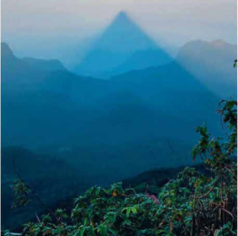
cloudforest and mountain views, but
it’s also a culture-rich endeavour,
taking in sacred shrines, chanting
sadhus, all-night chai-sellers and
prostrating devotees.
Thereareseveralroutesaroundthe
mountain. Most popular is to ascend
via the short, sharp 5,500-steps of e
the Hatton Route (7km), which
climbs from the village of
Dalhousie; you could descend
the same way, or via the longer
Father’s Path (11km), finishing in
Ratnapura. Most pilgrims set of
in the small hours – during the
December-to-May pilgrimage
season, the route is strung with
lights. The aim is to summit in
time for ira-sewaya – the sunrise
phenomenon – when Adam’s
Peak casts its pyramidal shadow
onto the misty plains below.
LIKE THAT? TRY THIS... Koyasan
Choishi Michi Trail, Japan (23km),
a one-day pilgrimage trail –
which can be made shorter by
train – to reach the temples of
sacred Mount Koya.
DIFFICULTY: Moderate–tough
Rising 2,244m from the tea-cloaked
Central Highlands, Adam’s Peak is
Sri Lanka’s premier pilgrimage
destination. A sacred footprint,
appropriated by many faiths, is said
to sit on its summit, and thousands
of Buddhists, Hindus, Muslims,
Christians and curious hikers make
the climb each year. The trail rises
past plantations, butterfly-flittered
cloudforest and mountain views, but
it’s also a culture-rich endeavour,
taking in sacred shrines, chanting
sadhus, all-night chai-sellers and
prostrating devotees.
Thereareseveralroutesaroundthe
mountain. Most popular is to ascend
via the short, sharp 5,500-steps of e
the Hatton Route (7km), which
climbs from the village of
Dalhousie; you could descend
the same way, or via the longer
Father’s Path (11km), finishing in
Ratnapura. Most pilgrims set of
in the small hours – during the
December-to-May pilgrimage
season, the route is strung with
lights. The aim is to summit in
time for ira-sewaya – the sunrise
phenomenon – when Adam’s
Peak casts its pyramidal shadow
onto the misty plains below.
LIKE THAT? TRY THIS... Koyasan
Choishi Michi Trail, Japan (23km),
a one-day pilgrimage trail –
which can be made shorter by
train – to reach the temples of
sacred Mount Koya.


0 Comments